Quality City Planning Is Setting a Community Up for Success--And Results
Last Updated: June 13, 2024
City planning is downright controversial in some places. The very idea of planning by the government somehow sounds suspect. This is especially true in smaller places where there is not much new real estate development.
We agree that government is not always effective, efficient, and thrifty. But based on many serious conversations with people who thought they were against city planning, our experiences lead us to ask if you are sure you want to be against all planning. All of us plan constantly--what to wear, where to shop, what we'll do with our next paycheck, what to eat for dinner, how to get a promotion, and what to do when the sofa wears out.
In this section of the website we will equip you to participate fully in a community planning process that is responsive to residents and businesses rather than a diabolical plot against freedom. We promise that we will show you how to evaluate your town's planning program too.
The grid below contains links to the pages in this section, or use the search box at the top of the page to find what interests you. Our article about identifying quality planning resumes below all of those choices.
Topics in This Section: Community Planning Process -- Land Use Planning -- Land Use Principles -- Land Use Classifications -- School Site Selection --Street Hierarchy -- Walkable Community -- Bikeable Community -- Community Engagement -- Comprehensive Plan Contents --The Smart City and Planning -- Charrettes -- City Planning with Kids -- Neighborhood Planning -- Neighborhood Demographics -- Transportation Planning -- Complete Streets -- Watershed Planning -- Conservation Easements -- Open Space -- Wildfire Prevention -- Land Subsidence -- Driverless Cars and Planning -- Autonomous Vehicles and Transit
Topics in This Section:
Depending on specific conditions in your community, you probably are interested in some more transportation-related topics, which come next.
Finally, good city planning could entail any or all of the following topics. The last photo link on this grid contains a short form where you could tell the world about what you think is the best city plan--or see what others have written.
Three Benefits of City Planning
1. Planning creates lasting value in a community, as opposed to a more disorganized process by which a series of developers build a flashy store, strip center, or subdivision that looks great for awhile until it goes out of style. When residents have contemplated their future and anticipated what is likely to happen, they will create a more versatile community that can adapt to changes in lifestyles, preferences, and economic trends.
2. Thoughtful planning tends to result in a wider variety of choices in types of housing, places to shop, offices and workspaces, and options for businesses wishing to locate in a community. When a planning and zoning commission and a city council keep up with the times, for example, they see that more people want to work at home and are able to do so, thanks to technology. They then will analyze the implications of the shift from a large crowd of office workers downtown at lunchtime to workers venturing away from home only at dinnertime to pick up some take-out food.
3. Creating or updating a plan allows citizens, business interests, neighborhood representatives, activists, and civic leaders to come together every few years to understand one another's needs and requirements better, and then to figure out how to balance competing community needs.
These occasional formal planning exercises offer everyone a voice in the decision making about overall goals, objectives, and strategies. Conflicting needs will be brought out into the open, but with skillful facilitation, this can result in a stronger sense of community and unexpected win-win solutions to problems.
It's just that somehow when the government thinks ahead--even a mostly trusted local government--people worry about too much government control. Private property rights are a big deal in the U.S.
We're sorry if the term city planning confuses you. It's just the name of the discipline. The methods and processes apply equally to regions, counties, towns, very small towns, and rural areas that want to work together.
Who Plans?
After years in the city planning field, I think the central question is not "Is planning good?" but rather: "Who plans?"
Developers will be glad to figure out land use and transportation for a little piece of your community, often at the expense of other neighborhoods.
The people who bought real estate first in your neighborhood sometimes protect their own economic interests rather than thinking hard about the future of the entire citizenry.
Someone always plans your community, regardless of its size. The question is who. We have four suggestions.
1. The Public
If you want city planning in the public interest, to protect the broad population, you will need to involve ordinary citizens through community engagement. I don't mean having a public hearing either. I mean something that will make people get interested, and stay that way.
Why is community involvement essential? Because you want the buy-in. You want people to support and refer to the finished city planning product and not constantly try to cut it down to size. You also want people to have a speck of forgiveness and patience if something goes wrong along the way, as it inevitably will.
But to get buy-in, you're going to have to let people really have their say. And yes, there's a danger they will make bad decisions, but that is why you should enlist some really wise people for your team.
2. Specific Stakeholders
Besides the general public, you may need to think about involving your stakeholders (people who have a stake in the outcome) regularly in city planning. A stakeholder can really jump start or detract from implementation.
Examples are major businesses, institutions such as schools and universities, utility companies, the state highway department, railroads, federal installations in your town, and churches and other organizations that may be important in civic life.
While a company shouldn't necessarily have more voice than an individual citizen, that company's capacity to make or spoil the town means that the company should be singled out for their input.
Especially when there are some obvious major stakeholders, whether they are organizations or individuals, you may want to consider the intensive charrette method.
3. Children
One more group actually has the most to gain or lose from a future-oriented activity such as city planning. That would be the children. City planning with kids isn't for sissies, because kids tell you the truth, state the obvious, and don't stand for a bunch of silly jargon words that don't really mean anything.
Ask them what they think the town should be like in 5 or 10 years. If they say more ice cream, is that really such a bad idea?
4. Professionals
Ideally you'd have some smart, open-minded professionals looking over your shoulders to point out unintended consequences. In larger towns and cities, these may be paid permanent staff, or you may hire city planning consultants from time to time.
If you can't afford professionals, imitate what professionals do in other places. Their finished products are easily available on the Internet.
5. Everyone
Lastly, we think there is a decided trend toward democratizing data, as digital technologies make it easy for everyone to share lengthy and short reports, data, maps, and visualizations. GIS technology (geographic information systems, or layered systems of computerized maps) is now available to ordinary computer users at home. Beyond that, smart city innovations, in which data from various sources is shared across systems and have the ability to alter the performance of systems, make it possible for residents to understand the interaction of characteristics of a city much more wholistically and quickly.
Comprehensive Plans Compared to Neighborhood Plans and Three More Specific Types of Future Visions
Plans may be "comprehensive" or "master" plans, attempting to address all important aspects of community life that the local government impacts. Some places call this the "general plan" also.
Few places meet the goal of being truly comprehensive and inter-linking all the important topics that comprise a community, however. This section includes a discussion of likely comprehensive plan contents.
Also there are many possible sub-types of specialized plans, limited only by the specific conditions applicable to a particular geography and social system. In general, we would divide plan types into physical plans, economic plans, and social plans. Somehow in the U.S. physical plans have become almost synonymous with the term city planning and are even passed off as comprehensive plans in a typical city. But we want to point out that the planning methodology applies equally to other types of community issues.
Neighborhood plans address a smaller area and may be a combination of physical, economic, and social plans. They offer the opportunity for an area to differentiate itself from other neighborhoods. In urban areas, that differentiation supports the real estate market and keeps business humming.
Many small area plans are written for corridors, commercial districts, industrial areas, downtowns, or redevelopment districts.
Specialized plans addressing particular issues also may be prepared. For instance, a community experiencing rapid growth in immigrants from a different culture and language might write a plan for assimilating the new community members more effectively. Another example of what we are calling a specialized plan is a general economic development or job creation plan.
Stages in the Planning Process
We'll simplify and call it four steps, but you may want to visit our page on community planning process, where these are elaborated in more detail and described differently. Here is what to expect when your community engages in a quality city planning project.
1. Gather information and data, including maps and statistics.
Neighborhood demographics are important. Demographics means characteristics of the population, such as age, gender, income, ethnicity, and so forth.
You also will need to know what state highway departments and federal agencies might be thinking, and how developers and prospective residents view your community. Find out what the business community thinks of your city and whether it is concentrated in expanding or contracting sectors of the economy.
Start thinking early about what maps probably will be necessary to show existing conditions and your future plan. Determine whether you have the capability of producing such a map. If not, GIS (geographic information systems, or computer-produced mapping capacity) is increasingly common. A larger government nearby or even a utility or industry might be a mapping partner.
Once you've gathered what is likely to be a formidable amount of city planning information, including public attitudes and opinions, you begin sorting through it to see what is important.
2. Analyze existing conditions.
Figure out what is interesting, intriguing, problematic, or unusual in your data and information you have gathered. Try to distill what it means. Ask experts what they think and read this website, and rely on your own intimate knowledge of the community as well.
Analysis might include projections of existing or desired trends out into the future.
Will your town grow? (Of course you think so, but is there any evidence of that, such as a historical trend or a new major employer nearby)? Will your town grow its boundaries and gain control of growth on its edges through annexation? So what will be the population, and the composition of that population, in 20 years?
3. Consider city planning alternatives.
Start putting together "what if" scenarios. What if we could get rid of that ugly vacant lot in the middle of town? What if we could reconnect Main Street through where that old factory interrupted it? What if we try to bring artists downtown to live and create some 24-hour-a-day presence there?
What if we say that all new developments have to be north of the stream, because we're going to keep south of the stream as open space? What if we look at our analysis and say that with our uneducated workforce, we have no chance of competing with our neighbors to the north for back-office operations, so we'll make warehousing our growth industry? What if present trends toward ride hailing rather than private automobile ownership, rentals of rooms and apartments through online platforms, and working from home and co-working spaces rather than in offices continue?
4. Decide on the future of your community.
Then lastly, you make some decisions. When we say "you," of course we mean a plural you that includes the citizens. You decide as a community it's logical to separate residential from commercial land uses--or not. You say we want to double the population, or not. You figure out that you have a competitive advantage economically if you attract even more doctors' offices.
Writing down these decisions so that everyone can see the plan is very important, but most places invest way too much money and energy into a glossy plan.
A great plan explains how the recommendations can be implemented, and will take a community in its desired direction, regardless of whether it looks good or sounds impressive. Pretty colored maps may or may not mean something, but most of them don't.
Obviously, that's an opinion. You might not agree. That is one reason that I am making it possible for you to contribute your idea of the best city plan you've seen, done, or heard about right here on this website. The form shows up on linked page. It will be exciting to see what our collective wisdom tells us.
How to Evaluate Your City Planning Program
Here are the questions to ask yourself about the effectiveness of planning efforts in your locale.
- Are these plans yielding the intended and described results? To be fair, many city plans require several years before they come to fruition, but if there is never any movement in the described direction, maybe the plan is unrealistic, too ambitious, not ambitious enough given the scale of the problem being addressed, not in tune with what developers will actually build, or lacking in perception of larger economic, social, and political trends.
- Do citizens, residents, property owners, and businesses continue to feel included in decision making to the extent they wish? This does not mean that every protesting neighborhood group is right about what they think they want, but it does mean that they are heard and that the government is transparent in its decision making.
- Does the planning program unfold in the simplest possible manner that will lead to acceptable results? Many jurisdictions now seem trapped in an ever-increasing web of complexity that manages to alienate residents, confuse businesses and developers, and heighten the tendency of professional planners to act like bureaucrats instead of the competent public servants, creative thinkers, and community organizers that many of them want to be.
- Does the sum total of the planning decision making, including that of the governing body, seem fair and impartial? Any hint of favoring one part of town over another, or giving one developer more favorable treatment than another, should raise suspicions.
- Is the result of planning equitable rather than equal? It is a mistake to regard all parts of a city, town, or region as needing the same treatment. Often conditions are quite different, and past and present inequities in quality of public services have created gaps in wealth, beauty, and functionality that should be addressed on the basis of equity rather than sameness.
Most Important Topics in a Physical Plan
Since we acknowledged that the physical plan is dominant in the U.S., let's talk about what's usually included in such a plan.
For the physical side of a comprehensive plan, the most important key decisions will lie in the four areas discussed below.
Land Use
This means whether the land is used for residential purposes, or whether it is commercial, industrial, office, cemetery, institutional (schools, churches, charities, and so forth), public (government buildings or facilities), agriculture, open space, park, and so forth. There is no one correct list of land use classifications, and the subject is complex enough to have its own page. Use what fits your situation.
Sometimes the residential category is divided by densities; density means the number of housing units per acre or square mile. Usually single-family homes are listed separately from multi-family, and sometimes mobile home parks are considered separately as well.
The idea is to start thinking about the future layout of all the activities that make up a community, according to a set of land use planning principles. If we put all of the houses together over here on one side of the river and all of the shops on the other side, is that a good thing or a bad thing?
I've spent a lot of time trying to convince people that they have to segregate different activities from each other, because that's what I learned at the university. But there are many advantages to some degree of mixed-use development.
We will also add consideration of annexation of land into a town or city, since development outside of official city limits often leads to problems for the city later. Rational boundaries make for better neighborhoods in the long run.
Transportation
Transportation planning traditionally referred to highways, roads, and streets in the U.S. Really inclusive transportation plans, such as those undertaken by regional organizations, might also address freight, ports, and airports.
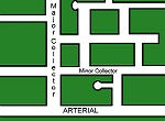
There should be a hierarchy of roads allowing some streets to be faster moving with fewer interruptions. Similarly, there is a street hierarchy within a town or city. The key streets in a town usually are called arterials, and the street coming out of a subdivision, for example, may be called a collector because it collects traffic from minor streets. Other lists of street and road types are possible.
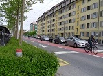
However, we highly recommend that you become more progressive and consider a complete streets approach, in which transit, pedestrian, and cycling modes get equal rights. To do so, you will need to plan for a walkable community and a bikeable community. You also will have to consider what impact driverless vehicles will bring.
The key transportation planning goals are providing a choice of modes (examples of a "mode" are driving, walking, taking a bus, or bicycling), connectivity, and redundancy, both to relieve excess traffic on one mode and to provide alternatives in case one pathway is blocked due to accident, maintenance, weather, wildfire, or other event.
School Size and Siting
This is an unconventional topic for city planning, but let's think for a minute. If school planning can be integrated into city planning, so that huge schools aren't being built on the outskirts of town, benefits include more walking to school, more kids being known and noticed, less sprawl, less abandonment of historic school buildings, and better opportunities for school-community interaction. School site selection and neighborhood planning should go hand in hand.
Natural Environment Topics
Open space may take the form of parks, preserves, conservation areas, or simply undeveloped land. I put open space on an equal footing with land use and transportation in determining the physical plan for a town because open space is often rather easily obtained to stop growth in one direction and redirect it to another. Also city planning that preserves open space allows protection of floodplains or other environmentally sensitive lands such as wetlands, beaches, or mountains.
Of course, climate change planning is justifiably a hot topic (oops, just couldn't resist a pun). Many of your communities need to begin in earnest to figure out ways to mitigate the damage to property and humans from climate changes. Don't wait until the hazards are simply too great for most people to consider your town livable.
If your local folks hate regulation, you can use privately negotiated conservation easements for implementing sound land use and open space policies.
Related to both land use and open space, smart planning for wildfire prevention and mitigation of other natural hazards, such as storms, earthquakes, and mudslides, is critical in some geographies.
Useful Rural Plans
One of the toughest challenges is making sensible rural plans, discussed on a rural zoning page. Sometimes it seems as though the assets and options are outweighed by the overwhelming lack of a future during those times when agriculture is depressed, light industry has left the country, highways bypass a small town, or myriad other causes of the decline or isolation of a rural area.
However, formulating a common vision for a rural community is incredibly important.
Believe it or not, the process is exactly the same in a rural situation as in city planning. Only the priorities among the topics differ.
- Making and Keeping a Good Community > City or Community Planning
Join GOOD COMMUNITY PLUS, which provides you monthly with short features or tips about timely topics for neighborhoods, towns and cities, community organizations, and rural or small town environments. Unsubscribe any time. Give it a try.
